Bloom Spatial Launches First AI-Powered Vegetation Management Platform Built Specifically for Electric Co-Ops
Ask Questions in Plain Language, Streamline Member Notifications, and Spot Risks Early. No GIS Degree Required.
BLOOMINGTON, IN, UNITED STATES, October 9, 2025 /EINPresswire.com/ -- Bloom Spatial announces its vegetation management platform, the first system designed by and for electric cooperative utility vegetation managers. The product was developed in partnership with SCI-REMC, 30,000 member electric co-op headquartered in Martinsville, Indiana. The platform addresses co-ops' unique vegetation management challenges with technology that's powerful yet practical for field teams.
The platform combines remote sensing data (satellite, aerial, LiDAR, and others) with operational data from the utility to yield actionable insights for co-op operators.
Industry-First Spatial Intelligence Chatbot
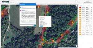
Bloom Spatial introduces the vegetation management industry's first spatial large language model (LLM) chatbot. System vegetation managers can simply ask questions in plain language: "Which span is the most critical?" or "Show me areas where we've deferred maintenance beyond our cycle," and receive instant, map-based answers with actionable insights. No GIS expertise or complex queries required.
This breakthrough eliminates the technical barriers that have kept valuable vegetation data locked in traditional GIS systems, putting intelligence directly in the hands of vegetation managers who need it most.
Built for Co-Op Workflows
Unlike generic utility software adapted for vegetation work, Bloom Spatial was purpose-built around co-op vegetation managers' daily workflows:
Integrated parcel data streamlines member notification by automatically identifying property owners adjacent to planned work areas, supporting the critical "information" and "respect for property" dimensions of member satisfaction outlined in NRECA guidance
Remote sensing technology identifies vegetation risks early using satellite and aerial imagery, enabling proactive maintenance scheduling before trees become outage threats
No PhD in GIS required. The intuitive interface is designed for vegetation crews, not data scientists, ensuring adoption across all experience levels
Smart work prioritization combines vegetation conditions, outage history, and maintenance cycles to schedule crews efficiently
Real-World Results from Co-Op Development
Developed collaboratively with SCI-REMC's vegetation management team, Bloom Spatial reflects actual co-op needs rather than theoretical requirements. The platform handles rural service territories' unique challenges—scattered tree densities, long cycle requirements, contractor coordination, and budget constraints that differ significantly from investor-owned utility conditions.
"In the cooperative world, Bloom Spatial shines as being truly partner-driven,” said James Tanneberger, CEO at SCI-REMC. “They asked us the right questions, paused to listen, and let us tell them what we wanted to see. The result is a customer-designed tool that actually solves our problems like none other in our space. It has been a great partnership, and it's refreshing to see a solution tailored specifically to what cooperatives need."
"We built Bloom Spatial to solve problems actually faced by co-op vegetation managers," said Pablo Fuentes, CEO. "The spatial chatbot means vegetation managers spend less time wrestling with software and more time making decisions that improve reliability. Integrated parcel data simplifies member notification, and remote sensing, such as satellite and aerial imagery helps us identify issues across thousands of miles of line without needing an army of scouts."
Flexible Pricing for Co-Op Budgets
Bloom Spatial offers tiered pricing based on service territory size and miles of line, with special consortium pricing for regional co-op alliances sharing services. Implementation includes training for vegetation management personnel and integration with existing systems.
See Your Service Area
Bloom Spatial provides customized demonstrations using each co-op's actual service territory, showing how the spatial chatbot, parcel integration, and remote sensing work with real vegetation conditions and circuit layouts.
Visit bloomspatial.com or contact us directly at contact@bloomspatial.com to schedule a demonstration using your service area.
Pablo Fuentes
Bloom Spatial
contact@bloomspatial.com
Visit us on social media:
LinkedIn
Legal Disclaimer:
EIN Presswire provides this news content "as is" without warranty of any kind. We do not accept any responsibility or liability for the accuracy, content, images, videos, licenses, completeness, legality, or reliability of the information contained in this article. If you have any complaints or copyright issues related to this article, kindly contact the author above.

